Where’s Colin? He’s at an ACSI campsite at La Garrofa, at N36 49’35”, W2 30’59”.
Yesterday’s progress down the coast amounted to, at most, 10km. As I said the other day, we’ve been moving slowly. We could happily have spent another couple of days getting to Almeria too, spending a day or so at the Cabo del Gato Parque Natural and paying a visit to Nijar on our way past. A lesson was learnt at Orihuela, though, when we found the museums to be closed on a Monday and a check of the guidebook confirmed that the same applies here. So, Almeria became our destination for today, preferably early enough to do the laundry I was unable to do in Vera the other day.
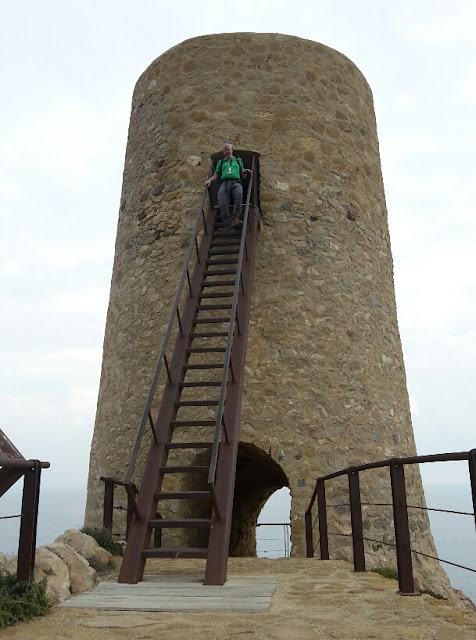
We didn’t dash straight off first thing from our lovely overnight spot, however, as there was a walk to be had, involving a mini-castle, a tower with a scarey ladder and a couple of hilltop viewpoints (more of which at gayleybird.blogspot.com).
Hitting the road just before noon, with a 70km journey ahead of us (I think that’s the furthest we’ve moved in a day since we got down to southern Spain) we had every intention of breaking it up with a coffee break, just as soon as we found a shop to solve our bread/pastries shortage. First though we had some hills to get over, offering some spectacular scenery for me, and some wiggly roads for Mick:
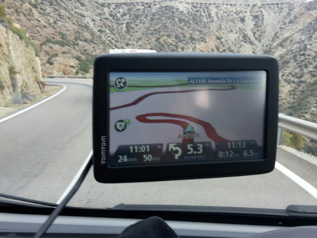
The red line shows the wiggliness of the road, and if you look above the satnav to the very top of the snap you’ll see that the hillside being hugged by the road is so steep that it required the tarmac to be supported by pillars on the outer edge.
Arriving in the only town we were to pass through, we failed in our quest for bread. The one shop where we were able to park turned out to be closed for refurb, and parking was too difficult near to the other three. Thus we hit the motorway with stomachs rumbling.
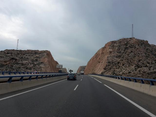
Much road engineering! There were dozens of these cut-throughs and quite a few viaducts too.
“Take us to our campsite” I said to the satnav. “Can’t” it said “Not possible”. I tried programming in a couple of other places along the same bit of coast, but kept getting the same answer, that there was no possible route. The satnav was duly cursed. This so hot on the heels of an incident two days ago when it tried to take us 10km (drawing three and seven eighths sides of a square) to get us to an Aire which was almost next to us. All was forgiven when we discovered that actually the road to the campsite is restricted use, for residents and campsite users only. I suppose I can’t really expect the satnav to know that we were genuine users (although I do wish it had a ‘stick to the coast road unless I tell you otherwise’ setting, and there was no excuse for the ‘go 10km around the block’ incident).
There’s not much to tell of our afternoon, unless you want to hear about the laundry? Nope, thought not. We did take a little stroll locally, but the strolling options were somewhat limited. Oh, and I finally worked out (with much Googling) how to make in-app purchases of individual map tiles in ViewRanger, so next time we find ourselves out on a marked trail, I will have the ability to download the relevant bit of map, if we so choose.
As for tomorrow, and the reason we’re here at this tired and in-need-of-some-TLC campsite* (albeit sitting in a nice location just off a cove), we’re off for a shufty around Almeria.
(*this is the first place we’ve been that has been full of British vehicles. Why are they all here and not other places we’ve been? We have no idea.)
Yesterday’s progress down the coast amounted to, at most, 10km. As I said the other day, we’ve been moving slowly. We could happily have spent another couple of days getting to Almeria too, spending a day or so at the Cabo del Gato Parque Natural and paying a visit to Nijar on our way past. A lesson was learnt at Orihuela, though, when we found the museums to be closed on a Monday and a check of the guidebook confirmed that the same applies here. So, Almeria became our destination for today, preferably early enough to do the laundry I was unable to do in Vera the other day.
We didn’t dash straight off first thing from our lovely overnight spot, however, as there was a walk to be had, involving a mini-castle, a tower with a scarey ladder and a couple of hilltop viewpoints (more of which at gayleybird.blogspot.com).

Hitting the road just before noon, with a 70km journey ahead of us (I think that’s the furthest we’ve moved in a day since we got down to southern Spain) we had every intention of breaking it up with a coffee break, just as soon as we found a shop to solve our bread/pastries shortage. First though we had some hills to get over, offering some spectacular scenery for me, and some wiggly roads for Mick:

The red line shows the wiggliness of the road, and if you look above the satnav to the very top of the snap you’ll see that the hillside being hugged by the road is so steep that it required the tarmac to be supported by pillars on the outer edge.
Arriving in the only town we were to pass through, we failed in our quest for bread. The one shop where we were able to park turned out to be closed for refurb, and parking was too difficult near to the other three. Thus we hit the motorway with stomachs rumbling.

Much road engineering! There were dozens of these cut-throughs and quite a few viaducts too.
“Take us to our campsite” I said to the satnav. “Can’t” it said “Not possible”. I tried programming in a couple of other places along the same bit of coast, but kept getting the same answer, that there was no possible route. The satnav was duly cursed. This so hot on the heels of an incident two days ago when it tried to take us 10km (drawing three and seven eighths sides of a square) to get us to an Aire which was almost next to us. All was forgiven when we discovered that actually the road to the campsite is restricted use, for residents and campsite users only. I suppose I can’t really expect the satnav to know that we were genuine users (although I do wish it had a ‘stick to the coast road unless I tell you otherwise’ setting, and there was no excuse for the ‘go 10km around the block’ incident).
There’s not much to tell of our afternoon, unless you want to hear about the laundry? Nope, thought not. We did take a little stroll locally, but the strolling options were somewhat limited. Oh, and I finally worked out (with much Googling) how to make in-app purchases of individual map tiles in ViewRanger, so next time we find ourselves out on a marked trail, I will have the ability to download the relevant bit of map, if we so choose.
As for tomorrow, and the reason we’re here at this tired and in-need-of-some-TLC campsite* (albeit sitting in a nice location just off a cove), we’re off for a shufty around Almeria.
(*this is the first place we’ve been that has been full of British vehicles. Why are they all here and not other places we’ve been? We have no idea.)
No comments:
Post a Comment