Sunday, 14 February 2016

Sunday 14 February – Palmone, La Linea and Gibraltar

Where’s Colin? He’s in the car park of the football ground at La Linea, with quite a few other motorhomes of various nationalities (but mainly British registered), at N36º9’30”, W5º20’20”. There are no facilities (except for a rumoured sewer manhole cover that can be lifted), but then it only costs €3 for a day and a night.

It was, once again, to rain that we awoke this morning. Not the sort of weather that made walking around Gibraltar appealing, so the plan was formulated to overshoot Gibraltar and head to Palmone, where we could spend a chunk of time reading our books and drinking tea, before having a nice lunch at a friend’s cousin’s restaurant, Casa Mané.

The first part of the plan went well. The restaurant was located and with a nice sea view we parked up and made inroads into our books. The sun even came out every now and again and we snatched one such opportunity for a walk along the beach (two British people stopped by our pitch on the campsite this morning to chat about the weather and both informed us that it was going to be very windy today; they were right - we got thoroughly sandblasted during our shoreline stroll).

At quarter to two we decided it was a reasonable hour to go for lunch, which coincided with three other cars simultaneously arriving, their occupants going to the restuarant and then immediately returning to their cars. This didn’t look good, and it wasn’t. We were met at the door with the news that the place was booked out. What we’d forgotten at some point between waking up and formulating our plan was that it wasn’t just a Sunday (a day when we assume restaurants are busier than they are during the week), but it’s also Valentine’s Day.

Momentarily thrown, we soon had a new plan: back a little way we would go, to Gibraltar.

There’s Gibraltar, just over the water from Palmone. It’s a little further to drive around by road.

Until yesterday’s campsite, our previous 13 night’s accommodation costs had come in at a whopping total of €15 and, thinking that the €12 Aire at La Linea would be our home for the next couple of nights, it was looking like we were about to enter a comparatively expensive period. However, one of the British-bearers-of-gloomy-weather-forecasts this morning mentioned to us the parking at the football stadium and that rang a bell in my mind. I checked the Park4Night app, and as we don’t currently need any facilities, we thought we may as well go for the €3 option rather than the €12 one. In fact, we could have parked out on the road for free, but even though this place has no security, €3 seemed like a reasonable price to be in amongst plenty of other vans, at least some of which are likely to be occupied when we’re out.


Getting closer…  Note the palm tree and the wind-sock – it was a tad breezy!

It was late afternoon by the time we walked the half kilometre (into the wind; it was still blowing some) back to the border, where only passing glances were given to our UK passports. Once across the runway, the first things encountered are two petrol stations. Fifty-nine pence per litre for Diesel. Pity Colin’s not got a lot of capacity at the moment – I’d take the trouble to drive over the border for that price!

We didn’t progress an awful lot further, as we happened to pass a pub door which was immediately opposite one a TV screen and, having established that they were showing the England rugby game, in we went. Finding that they had the Liverpool game on too made Mick a very happy chap:

We did manage to fit in a stroll up the main street (where almost everything looks so very British) before the time of day caused us to turn back for the border. We’ll be back to explore the place further tomorrow.

Saturday, 13 February 2016

Saturday 13 February – Casares and Estepona

Where’s Colin? He’s at an ACSI campsite just to the east of Estepona, at N36º27’15”, W5º4’51”.

Yesterday afternoon, as the rain drummed down, I planned for this morning. After downloading the Tourist Office’s booklet of walks in the area, I loaded the local map tile onto ViewRanger and then added to that the GPX files of three walks I’d selected. Those three files gave us options for a 1-hour, a 2-hour or a 3-hour circular walk, with the decision as to which to take to be based on the reality of the weather when we arose.

The reality of the weather was such that we took none of those options. Instead we walked a whole 100 yards to the nearby viewpoint, looked across at the village…

vaguely thought of walking over to it, got put off by the next shower coming in, had a brief chat with a gaggle of Brits who had met up in our car park (a walk had been their intention, but they too ditched that plan in favour of the indoor activity of coffee drinking) and made haste towards the coast.

It did feel a bit like all of those miles of sub-quality road* had been a waste, just to spend the night being battered by the wind and lashed with rain in a car park in Casares!

It didn’t take long to drop back below the cloud and what should we then see ahead of us, but a sunny coastline. Sunshine! Finally!

It was debatable whether we needed a campsite today (all of this driving around, combined with a low demand on Colin’s leisure battery, means that we’re not needing a campsite to plug into the mains as often as we would in the UK), but to maintain flexibility for the next few days we decided to divert to the nearest ACSI site, even though it was a 19km detour from our route to Gibraltar (where we’re heading next). Thirteen kilometres into that detour, a failure of navigation occurred (“Ignore the SatNav” I said “that’s not right at all!”) which not only put us on a toll road, but also sent us straight past our destination before we reached the next junction. Another 24km ensued.

The site, when we eventually got here, isn’t one at which I would want to spend more than an afternoon (and then I’d only want to be here in order to make use of the facilities, as we are). It seems a bit cut off and the pitches are very slender. Still, we’ve charged all the gadgets, got some laundry done, had long, hot showers and have had a haircut apiece (sorry, very dodgy photo – the camera focussed on the tail-light of the caravan next door and I couldn’t be doing with running back and forth to set up multiple attempts mid haircut):

We don’t have any outside chairs with us, but Mick rummaged in the skip on the pitch next to ours and found an old set of caravan steps which proved to be a perfect substitute for a barber’s chair.

Our afternoon stroll was brief indeed. As I said, this site is rather cut off, and having walked down to the beach (via a very small ‘public prohibited’ tunnel under the motorway) we couldn’t see anywhere else to go, so we came back. In the morning, we’ll head off somewhere more interesting.

that's a very big, droopy flower!

(*All those brand new motorways, with barely a car between them, are quite a contrast to the little roads which have suffered extensively from episodes of subsidence, giving an ‘interesting’ driving surface. This little road was the worst yet.)

Friday, 12 February 2016

Friday 12 February – Benarraba and Casares

Where’s Colin? He’s in a Municipal Aire, in a quite exposed location, just outside of the village of Casares, at N36º 26.775’, W5º16.710'.


View from Colin, when the cloud isn’t hanging right down into the valley

Whilst today didn’t dawn fine, it was dry and with a higher cloud base than the last couple of days, so after I’d presented Mick with a postcard and sung Happy Birthday to him, off we headed to walk route SL-A 175.

Due to the location of the village of Benarrabas, this circular walk starts with the downhill and ends with the up. As much as I’d rather have things the other way around, this was the only circular trail in the area, so off we went – steeply down.

I commented a couple of days ago about how green and forested is the area in which we’re now travelling and today we learned that we’re in a cork oak area. It was these trees, just a few minutes into our walk, which initially gave it away:

and a while later (just as we were wondering how long it takes for the bark to regrow) we came across an information sign telling us that the valley side on which we were standing is split up into ninths, with one being harvested each year on a 9-year cycle.

very green!

The down went on violently for some time until, after crossing a stream and ascending a little way the other side, I began to get suspicious that we weren’t on the right path. In fact, it seemed to me that we were on the wrong side of the valley. I’d not been able to find a gpx file for this route (and I now believe that’s probably because no-one has been able to follow it in order to record a track!), and the map on the official leaflet was so lacking in detail as to make it only of marginally more value than that on the information sign at the start point (which was a line on an aerial photo). However, the map on the leaflet (which I had downloaded onto my phone) did have some contour lines, telling us that we shouldn’t have dropped below 350m. We were now at 280m…

Back we went, huffing and puffing up the steepest section, to get to a multi-way junction we’d passed a while before and we duly explored all possible other tracks. All options were explored, without a single waymark being found, before we conceded defeat and headed back the way we had come.

By then a light mizzly rain was falling, so any passing thoughts of trying the circuit from the other direction were pushed firmly out of my mind, and via the village shop (for the poorest imaginable excuse for a birthday cake) we headed back to Colin.

Having moved on to Casares (along the worst quality of road yet encountered in Spain), where there are plentiful walk options, Mick vetoed the notion of going out again, pointing at the rain being lashed at Colin’s windward window:

So, once again we hope for better tomorrow (only two more days before the forecast turns good again, but we’ll be back on the coast by then).

The eventfulness of the afternoon has therefore been witnessing a driverless car (and not in the manner of modern technology) roll backwards across the car park, coming to rest on a kerb and against some road signs. Mick managed to locate the owners in the Tourist Office – a couple from Basingstoke. They were quite relaxed about what had happened “At least it’s ony a hire car!” they said.

(For anyone reading both this and my walking blog over at gayleybird.blogspot.com, I've saved you some reading as I've lazily duplicated this post in both places today.)

Thursday, 11 February 2016

Thursday 11 February – Benarraba

Where’s Colin? He’s in exactly the same place as he was yesterday.

Rain drummed down on Colin last evening and last night and it was still going this morning. We sat here, looking out at the greyness and thinking that the surroundings gave promise of being quite spectacular, if only we could see them through the cloud.

There seemed little point moving on, as the weather would be the same in the next place we’re heading (it being not far down the road) and we quite like where we’re parked at the moment, so we sat around for most of the morning before dressing ourselves semi-appropriately for a strollette (waterproof trousers would have made our outfits more weather appropriate) and taking ourselves off for a look around the village. We came back dripping.

By early afternoon the persistent rain had given way to frequent showers and small patches of blue sky were occasionally seen. Out we went again, this time with improved visibility.

Thinking the rain would come back again any minute (we were wrong – we actually had a couple of dry hours) we didn’t go and walk the 3.9km route signposted from the village, but made do with another strollette around the tiny streets.

Otherwise, it has been a very quiet day, with much reading of books and we’ve even had a film on this evening.

The BBC weather service thinks that tomorrow morning will be dry. AccuWeather agrees (but then AccuWeather thinks that it can forecast continuous rain and 0% probability of precipitation on the same day…). Fingers crossed!

Wednesday, 10 February 2016

Wednesday 10 February – Olvera, Ronda and Benarraba

Where’s Colin? He’s at a municipal aire just on the very edge of the town/village of Benarraba at N36º32.957’ W5º16.751’

It rained last evening and intermittently through the night and quite considerably this morning too. Accordingly, we didn’t dash out but made more use of having electric and water to hand to have showers (twice in two days; how extravagant!) and then spent another couple of hours working on the laptop. Eventually, at 11.30 (half an hour before the ‘you must leave by’ time) we left the Aire. Having made multiple attempts to call both numbers shown on the information sign and enquired at the local restaurant, and in the absence of an honesty box, we didn’t feel too bad at making away without paying, as no-one ever did turn up to collect our money. Perhaps that’s why the price of the Aire has gone up 40% this year – the owner has realised he can still make the same money without needing to collect his fees every day.

View from the Aire (when the cloud lifted so we could see it)

The miserable weather put us off taking a walk along the Via Verde – a 38km-long stretch of old railway bed - but we did make an effort to take a quick look at Olvera. The verdict, having walked up to the church and castle, which stand prominently above this Pueblo Blanco (white town) is that they look better at a distance. Close to the church is actually quite shabby.


With another shower coming in, haste was made down from the church and we dived into the first coffee-serving establishment we saw, which looked quite busy as we walked through the door. Immediately I felt out of place; this didn’t look like a bar at all from inside, but a working men’s club (or, to be more precise, a retired men’s club). I was the only person in there under the age of 60 and the only female. Not put off, coffee was had, and we were stared at the whole time. I’m guessing they don’t have many foreigners drop in, but at least we gave them a bit of added interest in their morning and something to talk about!

Heading off and making a turn southwards after quite a few days of westerly progress, the change in scenery that we first noticed yesterday became more pronounced. Gone are the huge arid plains with small outcrops of hills dotted around and suddenly we are in a very green and hilly area, with woodland being a common feature. As much as it’s a nice change to see so much green, it does suggest that rain is to be expected.

Ronda hadn’t featured in my rough plan for the next few days, probably because there’s not an Aire there and I wasn’t feeling inclined to fork out for a campsite when we didn’t really need one. However, whilst sitting being stared at over coffee this morning, I had a quick look on Park4Night and armed with the location of somewhere we could park in the town, off we went.

I’ve since learnt, via a Facebook conversation with my friend Vic, that I would have visited Ronda 17 years ago if my friends hadn’t accidentally abandoned me for the day. I have no recollection of that abandonment, and thus no bad feelings at having missed this spectacular place. In fact, I had no idea that it was spectacular, not having read about it before we arrived.

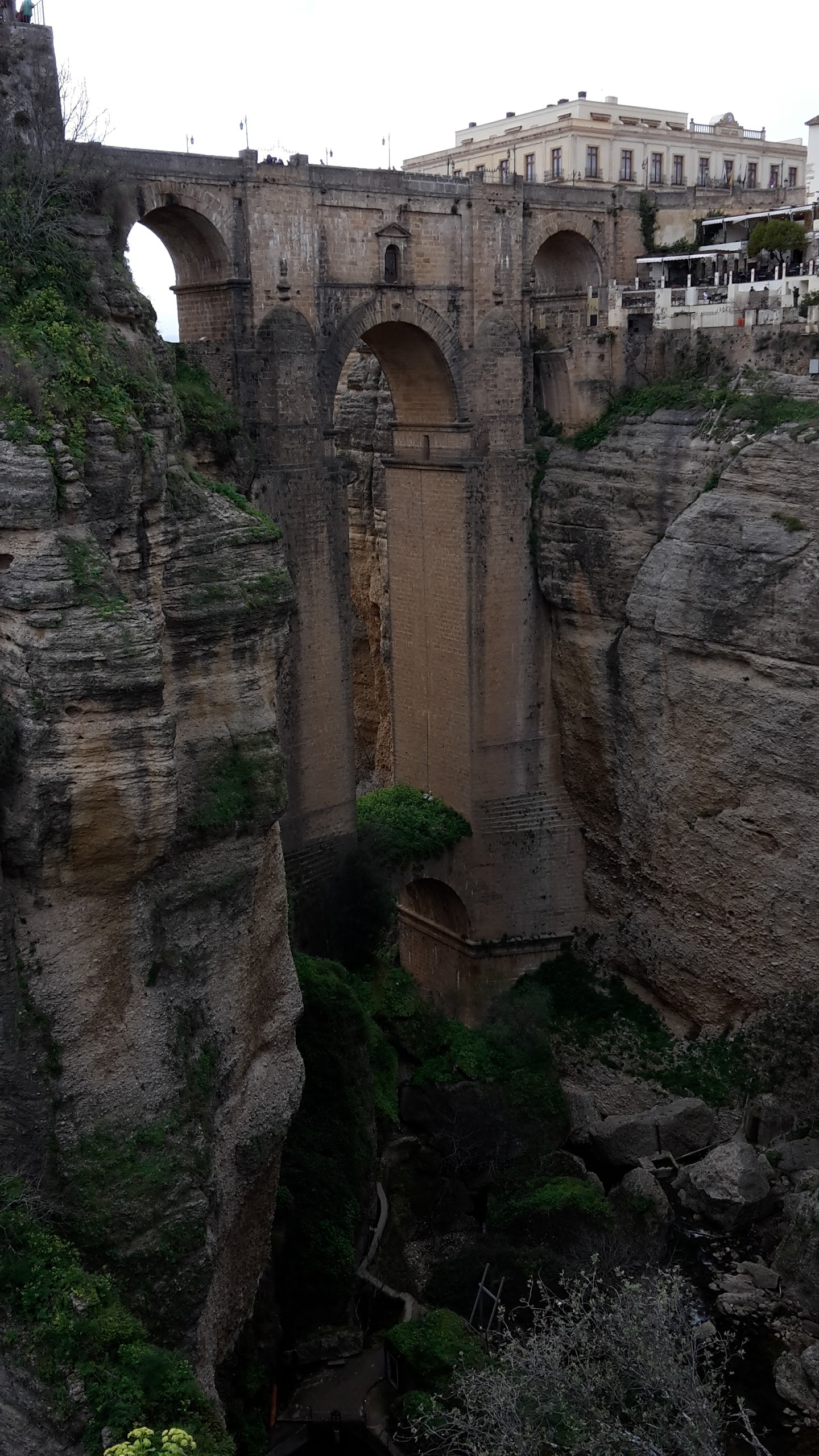
I’ll gloss over the lunch that we went for immediately upon arrival (we arrived at 2pm – the perfect time for lunch, we thought. It turns out that Ronda is so full of tourists that they probably don’t keep to Spanish hours so much), because it was decidedly below average and overpriced, but that disappointment was soon forgotten when we went for a look at the 130m-deep gorge which splits this town in two, and the bridge which spans the gap.

For once, I think my snaps do convey what it was like, and I’ve included photos from viewing points on both sides of the bridge, together with a snap of the gorge taken from the south, and of the escarpment to the north:


We could have spent the night in Ronda, but the car park didn’t really appeal to us, so onwards we moved again, slowly progressing along an undulating, wiggly road* to this Aire with 5 spaces, just on the edge of Benarraba. Seeing five vans in residence as we made our way down the road, we feared our luck was out, but one had chosen to park on the adjacent grass area, rather than in one of the marked bays (each with their own water point, toilet point and waste water drain!), so once more we got the last spot. We are again in the cloud, with rain falling, so we won’t be taking a walk into the town today. We’ll hope for nicer conditions tomorrow.

(*These undulations are not doing the MPG stats any good at all!)

(As an aside: Sometime yesterday afternoon my phone lost two key services – internet and phone calls (texts were still working). Was this because I’d been roaming for more than a month (contrary to Three’s T&Cs)? Had my month’s package ended half a day early? Lots of time was spent trying different things, eventually using a different phone to activate a new Three SIM and loading it with a month’s package. That didn’t work either. I can manage just fine without Facebook and without being able to blog, but the trip is being made so much easier by liberal use of Google Maps, and the Park4Night app is rather useful too, so it wasn’t a happy thought at having to manage without until I could source a local SIM. It was therefore a great relief when everything started working again at bedtime. I can only assume it was a network issue.)

Tuesday 9 February – Antequera and Olvera

Where’s Colin? He’s at an Aire at the old railway station, just outside of the attractive-looking town of Olvera. There are only 4 pitches at this Aire (nice generous ones, mind) but they each have electricity and a water points, for which the charge is €7 a night.

The Rough Guide says of Antequera that it is ‘an undistinguished, modern town, but it does have a number of peripheral attractions in a number of fine churches and a group of prehistoric dolmen caves’. It doesn’t make the town sound worth a detour or a special trip, does it? Contrasted with that description, what we saw was a very well presented town with an obviously long history and the Tourist Office gave me a map highlighting 57 points of interest, including a ridiculous number of churches, a castle, the Roman baths and the bull ring, as well as the Dolmen caves.

If you look carefully, there are a lot of large churches in this shot. Far more than seem justified by the size of the town (and there were even more out of the shot)


Having only been to the Alhambra two days ago, I didn’t think it worth spending €6 apiece on the castle but we walked around a section of its walls, enjoying the elevated view over the town and the adjacent remains of Roman baths (not the best example we’ve seen).

Back down in the town coffee called to us (and the barman managed to upsell second breakfast to us too) before we set out for the Dolmen Caves, to which we could have driven, but I didn’t think the 1.5km there-and-back walk would harm us.

By good fortune, we arrived at the Visitor Centre just as an English version of the information film had started, so we learnt how these chambered cairns were constructed before we viewed them. Unfortunately, the centre had run out of information leaflets in English and I’ve seen such conflicting information about the age of the structures that I can’t say for certain whether they’re from the 3rd, 5th or 6th century BC, but they do most definitely fall into the category of ‘very old’.

The first (of the two on this site) we came to was impressive to me, but Mick was disappointed as he’d expected something much bigger. The second one stunned us and took away all of Mick’s disappointment. It was huge: one of the roof slabs alone I paced out as being at least 7m by 8m. I imagine it’d be tricky to manoeuvre it into position even with mechanical equipment like a crane. Here’s a not-particularly-illustrative snap; the inside ones must have been taken on the camera, rather than my phone:

It’s hungry work looking around ancient structures, and as it was approaching 1pm it seemed (to our British standards) to be a suitable time for lunch, but we knew we were on the early side by Spanish standards. Indeed we were, and having walked back into town and sought out our chosen restaurant we learnt that we still had half an hour to wait until the kitchen opened, which meant that we wouldn’t be eating until gone 2pm and wouldn’t get away from the town until 3.30 at the earliest. Eating out thus became postponed for another day.

Quite impressively, we managed to incur the tutting disapproval of two different Germans before we left the Aire. Our first crime was daring to use the tap when it wasn’t our turn in the service point (the fact that no-one else was using it or waiting to use it was immaterial; the important fact was that we weren’t parked in the service point at the time). Once the service point was free and we took up position, we then incurred the wrath of a new arrival for draining our tank* even though we could see that the drain was blocked and that the water was spilling across the road. He would have had a point (and ‘everyone’s been doing this’ would not have been an acceptable excuse) if I hadn’t checked that in fact the water was running across the road and straight into a different drain.

Finally ready to move on, another 50-mile journey was had before we negotiated our way down a steep little lane to the Aire on which we are now sitting. We’ve made great efforts to pay someone for being here, but thus far have failed. Maybe someone will turn up in the morning to relieve us of our €7.

Arriving with a few hours of daylight remaining, ordinarily a wander would have been had, but greater priority has been given to stuff that needed doing on the computer whilst we had unlimited power, which combined nicely with the fact that it was raining.

The forecast for the next week features raindrops every single day. The question is: if it’s still raining in the morning, will we find the enthusiasm to walk all the way back up the hill to go and explore this interesting looking place?

(*I wonder if the same man would go down the road tutting at all the ladies who mop their floors and then throw the soapy water out over the pavement, to drain into the road? The contents of our tank are pretty similar, being mainly water, with a bit of soap and a tiny amount of toothpaste. I’m very careful about wiping dirty plates and dishes before washing them (to save our tank getting all mankey and the tiny outflow blocked with debris) and where possible I don’t empty the washing up bowl down the sink anyway (much quicker to walk to a suitable drain and dispose of the water direct than to store it and then wait whilst it drains out of a tiny hole.)

Monday, 8 February 2016

Monday 8 February – Antequera (via Parque Natural de El Torcal)

Where’s Colin: He’s in a completely full municipal Aire in the town of Antequera. N37º1.294', W4º34.331'

Last night’s Aire was definitely the least appealing yet. Aside from being ugly to look at, the adjacent road was busier than we'd expected. Even so, we both slept incredibly well, at least until a particularly loud lorry woke me at ten to six.

With a temperature of 8.5 degrees in Colin’s living area and 6 degrees in the front door pocket (the nearest thing to outside we can achieve without actually putting the remote sensor outside), I had a little rethink about the plan for the next few days and suggested a revision to Mick. We would skip the next couple of intended town stops, spend the day at El Torcal (but not the intended night because at over 3000’ it would be even colder up there) and would hasten our journey back south towards warmer weather. With Mick in agreement we leapt out of bed and got moving.

The Aire we’d originally thought to aim for last night was at Antequera, but based on the photos in the Aires book we decided that Archidona looked marginally nicer. However, I couldn’t positively identify the toilet emptying point there (it’s not the sort of thing you want to get wrong!), so as we were passing through Antequera this morning anyway we swung by the Aire and found that it wasn’t bad for an urban place – and that it was also very busy. It was only the briefest of pit-stops, before Colin’s nose was pointed upwards towards Parque Natural de El Torcal, which our guidebook had told us was ‘one of the most geologically arresting of Spain’s natural parks’.

We were well in the cloud base by the time we arrived in the visitor centre car park, so the usual delaying tactics of coffee and second breakfast were employed, with a pause half way through boiling the kettle to turn Colin around. I’d noticed that the wind was blowing a gale up there (people were staggering around fighting to get arms into their flapping jackets as they got out of their cars) and if we run the fridge on gas when the wind is hitting Colin’s offside then we get unpleasant fumes inside. Mick also took advantage of the free time to connect to the open wifi of a tour bus* across the other side of the car park, allowing him to download to his Kindle one of the books he bought a few days ago. Unfortunately, the bus moved off before he had chance to download the other; most inconsiderate of it!

A good few hours were spent in the park, which included a couple of walks (described on t’other blog at gayleybird.blogspot.com), and it really was spectacular, particularly when the cloud finally lifted after lunch. I’ll let the photos try to illustrate what was so good about the scenery:


As tempting as it was to spend the night (indeed, a handful of other vans obviously had already done so), we focussed on the temperate (we have enough cold nights in Colin in the UK; we want warmth over here!) and headed back down to Antequera with Colin’s engine screaming ‘Change gear for goodness sake!’, but with his brakes having a happier time than during the descent to Abla last week.
In our ongoing quest for some decent wifi, MacDonalds was our next port of call, via a cheap fuel station (86.9c/litre this time) and after a cup of coffee between us we came away with both of our Kindles loaded with the new books.

Prior to the pause at MacDonalds, the SatNav had been set for our next destination, but it was 4.30 by the time we were ready to head off so I gave Mick (as driver) the option of continuing as planned or just heading to the local Aire in town. He came down on the side of ‘had enough driving for today’, which combined nicely with my view of ‘this town looks much nicer than the guide books make it sound’, and five minutes later we were reversing into the only remaining free slot.

Two minutes later we were off for a quick tour of the town, which we’ll quite possibly explore further tomorrow (after I’ve posted this I’ll peruse the information I got from the Tourist Office this afternoon and find out what’s to see that we didn’t see this afternoon).  There seems to be quite a bit of interest here, including this church, which was the furthest point we reached in today’s wanderings:

The Church of San Sebastian. I found the Tourist Office’s web page for it whilst we sat outside, which gave us a quite comprehensive précis of its history.


(*I reckon that 90% of the people from the tour groups we saw got off their buses, walked to a nearby viewpoint which wasn’t that interesting then went to the café, without even setting foot on one of the trails to see the wonders of the area. What a waste of an opportunity! You’d only have to do a ten minute out and back stroll to see a good representation of the surroundings.)